Clackmannanshire has been focusing on expanding our active travel network. The area currently offers a variety of cycle routes connecting our villages and towns with an emphasis on providing a mix of both family-friendly, scenic, and more adventurous trails that link locally and to surrounding regions.
Our safe routes are designed to be accessible for all walkers, wheelers, cyclists, horse riders and non-motorised vehicles to enjoy and use for everyday journeys and leisure.
Clackmannanshire connects with surrounding councils through routes like the Forth Coastal Route, which links to Kirkcaldy and central Scotland, and plans are underway to further improve and expand our cycle network.
All of these routes offer a variety of experiences from coastal rides to mountainous paths, making Clackmannanshire a great hub for cycling enthusiasts.
Also known as Round the Forth, this is a popular route that connects Clackmannanshire with nearby areas like Stirling, Falkirk and Fife, passing through Alloa and following The Forth’s coast. It connects with both Clackmannanshire and Forth Road Bridges, offering views of the river and rural landscapes whilst catching glimpses of Scotland’s heritage and modern whisky industry.
Most of this route is traffic free but there are small sections on quiet roads.
Also known as The Devon Way, this is a 7-mile traffic-free path from Alloa to Dollar and is ideal for families. The route follows the old former railway line and winds through mature woodland. From Tillicoultry to Dollar the path is located parallel to the River Devon.
This route joins Tullibody with Menstrie, Alva and Tillicoultry and offers dramatic views of the Ochil Hills.
A brand new safe, off-road section between Menstrie and Alva has been created, along the former railway track. An alternative route exists on quiet roads between Menstrie and Alva, directly below the hillfoots and makes for a lovely, smaller circular route.
The route is approximately 6 miles between Tullibody and Tillicoultry.
You can connect the various routes and take in the Hillfoots villages, providing views of the Ochil Hills, Rivers Devon and The Forth. There are plenty of eateries and shops to stop along the way to make your cycle or visit a bit longer.
Our council area has seen the development of multi-use routes linking communities, schools, and services.
The Clackmannanshire Active Travel Strategy is currently being developed with public consultation to come. This will outline our future priorities for active travel in terms of where new routes can be established to encourage everyone to use our network of routes for all non-motorised travelling.
We have an equal focus on supporting sustainable travel in and outwith our area with our routes connecting to existing bus and rail hubs.
The Inner Forth Landscape Initiative has introduced a new bike bus, a hop on-hop off transport service around the Forth Estuary allowing people to explore Clackmannanshire’s heritage by bike before being returned home by bus. The meeting point is Alloa train station and the timetable can be found on the IFL website.
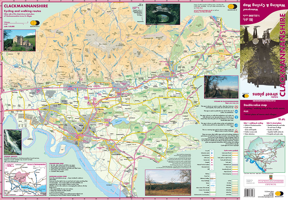
There are a range of maps to choose from including the National Cycle Network, which has maps showing a network of signed paths and routes for walking, wheeling, cycling and exploring the outdoors in the local area.
Our Active Travel and Core Paths are available via our Maps page and you can also refer to Harvey Maps cycling and walking routes map.
Clackmannanshire has been focussing on reducing barriers to cycling, walking, and wheeling. New, safe road crossings have been installed at Tillicoultry, Dollar and Alloa with other routes seeing improved safety measures, particularly around our schools. This work continues with funding from Transport Scotland.
Appropriate speed limits have been implemented on some road routes providing a safer environment for pedestrians and cyclists especially in, and linking to, residential areas with a focus on local access rather than through traffic.
Traffic calming measures including features like speed bumps, chicanes, and road narrowing has been implemented to discourage speeding.
Overall, there is a focus on our communities to serve local communities better and promote a sense of place whilst encouraging more social interaction.
Clackmannanshire Council is working on developing our 20 mph limits and zones on our residential streets, integrating cycle lanes where possible. Work is also underway to update our Local Transport Strategy to focus on accessibility and carbon reduction goals.
Work continues with the aim of establishing new active travel routes between Stirling and Clackmannanshire as part of the City Region Deal project. It means those using active travel routes between Clackmannanshire and Stirling, such as the National Cycle Network's National Route 76, will find it easier to seamlessly transition into the town or up to the Stirling town centre. Additionally, new routes between Alloa, connecting to Alva, will connect with Stirling University campus.
There are long term aspirations to improve cycling links with Falkirk and the restoration of an old railway bridge creating a dedicated shared use path from Alloa across The Forth towards Throsk.
Plans to create a cycling hub at Cambus are underway, allowing users of the NCN to either start or pause their journey next to the River Devon, with seating, bike shelters and a new tool station.
Roads & Transportation
Kilncraigs, Greenside Street, Alloa, FK10 1EB
Tel: 01259 450000
Email: roads@clacks.gov.uk